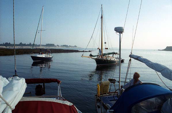
A two week cruise to Maine in Jabberwocky, our Freedom 28, along with Paul & Sally Merry in their Luders 33, Aurora. This was our first trip and sadly, this is the only photo. The camera broke and we didn’t know it until the negatives (remember film?) were developed.
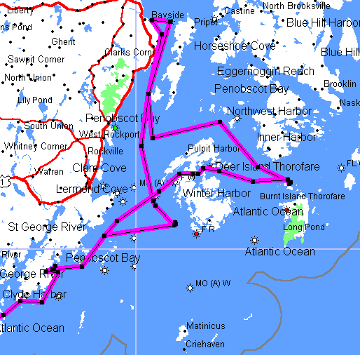
Tenant’s Harbor, Merchant Row, North Haven, Bayside, the White Islands.
date evening ? nm comment
Saturday, July 21 Onset M 0 Preparations
Sunday, July 22 Great Misery Island M 58 Good wind!
Monday, July 23 Isles of Shoals M 30 Via Annisquam
Tuesday, July 24 Jewell Island A 50 Good wind!
Wednesday, July 25 Tenants Harbor A 46 Via Davis Strait
Thursday, July 26 North Haven M 18 Brown & Son
Friday, July 27 Harbor Island A 11 Merchants Row
Saturday, July 28 Bayside M 30 Northport YC
Sunday, July 29 White Islands A 24 Against the wind!
Monday, July 30 Tenants Harbor M 15 Again Long Cove
Tuesday, July 31 Jewell Island A 46 Motor
Wednesday, August 1 Isles of Shoals M 50 Motor
Thursday, August 2 Winthrop M 46 Overheating!
Friday, August 3 Scituate M 17 Sailing!
Saturday, August 4 Onset M 37 Fog, here?
Part I, The Trip Up (chart-wise)
Sunday, July 22
Final frenzied preparations: fluids in and out: diesel, water, pump-out, ice, seltzer. With the last of the food and clothing, suddenly the great organization of the day before fell apart and there was stuff everywhere. We got off the mooring at 10:30 and into the Cape Cod Canal at 11:00 after joining up with Paul Merry in Aurora who’d spent the night on a mooring off Burgess Pt. Since the Canal current turned west at noon, this was cutting it close. Out of the Canal at 12:15 and we were off on a good SW. Paul had some trouble getting sails up on his Luders 33 and we took a lead never to be relinquished. Minor equipment failure: a lazy jack block “pinged” off its shackle; trussed it up with a bit of small stuff.
Was a fine wind all afternoon, shifting to W as the day wore on. Boat speed increased from 1.8 to 7.2; most of the time in the 6-to-7 knot range. Sails wing on wing, after removing the shock cord holding the camberspar to starboard. Passed across the edge of Stellwagen Bank, but saw no whales. Sunset brought a faint view of Boston as a smudge on the horizon, and a yellow haze that spread east from the power plants.
As darkness approached, we discussed by VHF where to go now that we obviously weren’t going to end up at Isles of Shoals, much less Tenants Harbor. Just the night before David and Jody Williams, headed south in their O’Day 28, had said you’ll never make it; keep Great Misery Island in mind – it has free moorings! So as darkness fell, we headed for the flashing green 4 sec of can “1” off Manchester and dropped sails as Paul caught up at about 9 pm.
This was our first ever night approach as we headed in the marks, looped around the island and picked around amongst the moorings. We ended up rafted on the best-looking of the moorings and had dinner. Although well protected, it was a very rolly anchorage and we ended up on separate moorings until breakfast.
Nan felt the island’s name was appropriate given our concern as we came into the unfamiliar waters under cover of darkness. We had felt our way in by chart, eyes and GPS. But reading the chart in the cockpit was difficult; no good in dark and too bright under flashlight. We need to come up with an appropriate light in the cockpit or perhaps just go below. Or get a chartplotter; the GPSmap 76 was extremely useful, from guiding us to the outside green can, to indicating the rest of the channel marks, but still does not have depths (at least until the CD comes out) and is also really too small easily to be read at night.
Monday, July 23
The usual great feeling in the morning; we’re all in one piece, the journey continues. After a slow start with breakfast, chores, chat and plans, we’re off at 10:30. Hey, it was Monday, no one had to go to work; this was vacation! I replaced the shackles on the lazy jack blocks with some from an old spare pair of blocks. With threaded pins, they are probably better for close contact with sails than the stamped shackles with cotter rings, anyway.
We motored up to Gloucester Harbor in the light morning wind. (Well, Paul rolled out his jib. “Freedom” may be not having to haul sheets, but rolling a genoa in and out is also pretty easy, even downwind. We hoisted our camberspar jib, but to little effect.) Again the yellow smoke trail across the sky. We passed the gracious mansions of Manchester (by-the-Sea if you please) and then the ostentatious palaces of Magnolia. (Why isn’t Ernie Boch here instead of Edgartown?) The harbor provided a taste of Maine, with lobster pots spread around the entrance.
Passed through the Blyman bridge at noon and out the other end of the Annisquam canal/river at 1 pm. At that point the plan was to try for Richmond Island, at Cape Elizabeth, where it looked like an anchorage would exist by the breakwater. So we sailed off together on 039. Really together; some times only six feet apart and then Paul pulled ahead on his larger jib, wing on wing. Until the wind dropped and the iron genny came on and shortly thereafter we altered course to 020 for Isles of Shoals, after some discussion of York. We’d had a late start, so if we stopped at Isles of Shoals, we’d not use all the hours of daylight. On the other hand, York would cost money for a mooring and would entail an in and out. And Richmond was unknown and by now too far. Not much to see in the haze; excitement was two boats motoring past on a reciprocal course!
The Isles were in sight by 4 pm and Paul hooked a mooring labeled GBYC around by the seawall between Star and Cedar Islands and we rafted up. After we’d taken Paul’s Profurl apart, two guys in another sailboat appeared and asked if we belonged to the Great Bay YC. Paul said no, New Bedford, so they asked us to let them use it. (Should one ask for ID in such a case?) Motored as one over to another mooring with a float made of a foam-filled barrel and a rusty eye. After the long day Sunday, it was nice to stop early and have time to relax, have dinner, talk and laugh and go to bed. And of course just look around; Isles of Shoals is (are?) a magical spot.
Tuesday, July 24
The early stop proved useful, as we were off the barrel by 9 am. 9:30 we passed Duck Island and were off on 045 for Jewell Island in Casco Bay. So where was the great wind promised by Sven? It was hazy and warm when the Yanmar came on at 10:30. At 10:35 a fly appeared – from the shore, the bilge or the diesel? We were forced to pull out our collector’s edition Cuttyhunk Store “Swat Team” flyswatter, bought the day the old back room store closed. A look over the stern showed the transom to be a staging area for the buzzing attacking forces. Does this support the engine theory?
Noon and the wind was up for real and we begin to move into the 5-plus knot range. By 3 pm we’d passed Biddeford Pool and boatspeed is up to 7 knots as we surf along, wing on wing. We were flying, rocking and rolling in the SW wind and the seas as we passed Cape Elizabeth at 4 pm! (Noting that Richmond Island does not look like a good anchorage.) As a challenge, I went below and made coffee; it’s always a sight to watch the stove roll back and forth. At 5:30 we arrived at the Green Island passage, as predicted by the GPSmap 76. As we sailed through, swaying from side to side, we passed an O’Day motoring on this beautiful day!
A few sailboats were anchored in the slot at Jewell Island and we motored in and joined them. Amongst them were our Coast Guard Auxiliary teachers from seven years ago. There was a thread on the CW BBS about whether CG and Power Squadron instructors actually have experience; Bob and Elyse Katz do! The wind howled at midnight and as high tide came, the seas rolled over the rocks at the SW end of the cut and we rolled for a couple of hours.
Wednesday, July 25
It was meet your neighbors time at rise and shine. During the night, the SW had kept the anchored boats in two neat lines. Now conditions were uncertain, and the four boats at the open end swung together so we could have passed toast and juice around! Exchanged greetings with the Friendship sloop and Newport 28 and heard tell of how they had been trapped for two days by the wind. That beautiful SW we romped on the day before? It often does seem windier at rest than it does when you’re out in it (especially moving with it downwind).
Up anchor was a remarkable (at least for us) 8:30 and we headed out for the inside route up to Tenant’s Harbor. Avoiding West Brown Cow and Drunkards Ledge, between Fuller Rock and Cape Small, inside Seguin Island, past the Cuckholds, past Pemaquid Point, past Egg Rock, through Davis Strait, past Port Clyde and up to Tenants Harbor. A lot of points, islands, rocks and shoals! Now we’re really in Maine; unfortunately mostly under power. From time to time we toyed with sailing, but it was mostly futile.
The points of the assorted Bays were fun to pass, but the real Maine experience came as we passed Egg Rock and then headed into Davis Strait. There were red and green navigational aids, but there seemed to be a lot of other brightly-colored things bobbing (and sometimes not bobbing) around – in and out of the channel. At first interesting, then annoying, then finally accepted as part of the landscape. Alert for the lobster pots, we also watched carefully for the channel, as it wandered back and forth, almost as much as in the Annisquam River. Paul called once on the VHF to ask if we saw the water rippling ahead. That, he said, was a shoal area, which we could avoid if we were to head for the correct green can.
Arriving at the entrance to Tenants Harbor (under sail!) was a real treat, past the beautiful island of the painting Wyeths, and then a right turn into Long Cove. (As we’d left Jewell Island, the Katzs had yelled, go to Long Cove!) Paul headed into the main harbor to seek out his wife Sally, who’d driven up. Long Cove was amazingly empty, with only half-a-dozen (okay, probably twelve) boats in sight. We picked a spot near one of the islands that shelter the cove and dropped anchor. A convenient line green and black lobster buoy provided an excellent mark by which to judge our holding. Having just read the Bernon’s anchoring article from Ithaka on the CW BBS, I powered full in reverse to set the Claw. With the lobster buoy as a guide, it was remarkable to see how far we rebounded on the nylon rode when the power came off! Perhaps less throttle next time.
Cuttyhunk has the Raw Bar boat with shrimp and oysters, Lake Tashmoo has the Peuwee II pump-out boat and Hadley Harbor this summer had a Sunday papers and ice boat. Knowing what cruisers need, Long Cove has a garbage boat! A youngster in a runabout took our bag of garbage for a dollar well spent. We pulled out the BugBusters and draped them on the forward hatch and companionway. Paul arrived to raft up, with Sally in hand, and we had drinks and cheese and peanuts, watched the weather front blow over and the beautiful sunset and enjoyed dinner. Ahhhhhh, we’d reached Penobscot Bay, and were finally settling into the feeling that now we reeeeeally were on vacation. As dusk took over, the winged warriors buzzed around, and we all ate below in our saloon.
Part II, Penobscot Bay
Thursday, July 26
The morning showed that the weather front had not passed after all, and it was raining in Long Cove. Spent time lolling around, reading charts and Tafts, and discussing where to go, now that we were here. Paul and Sally had an engagement in North Haven, so that would be the first stop.
We took off under clear skies at 1:15 for a trip up the Muscle Ridge Channel, under power. Leaving it at 3:15, we headed on a course of 075 for the entrance to Fox Island Thorofare, marked by an intriguing concrete pyramid, which separates North Haven from Vinalhaven. It was slow going, but we were determined to make it under sail. It was a pleasant afternoon, seeing Penobscot Bay spread out around us, and the faint sight of Matinicus Island to the south. We dropped sails at 5:15 at the beginning of the Thorofare; afterwards realizing that it is a large channel and sailing through it is not unreasonable. At 6:15 we grabbed the last of Brown & Sons moorings. I inflated the dingy and headed ashore to inquire about the showers mentioned in the Embassy Guide. Yes they exist, a sailor getting onto his dinghy told me, but the Market (which includes the showers) closes at 6:30. Not for tonight; hey, it had only been four days now without one!
We made ourselves respectable and headed into the town, hoping for dinner. Tied up at Brown & Son’s dinghy dock and walked up to Brown’s market which was, indeed closed for the night. Looked at Brown’s snack bar, but decided to seek out the restaurant mentioned on random signs. Finally discovered Brown’s Coal Wharf restaurant down by the water. Told us that we needed reservations, which could be made for 8 o’clock. The menu looked inviting, so we walked around North Haven for another three-quarter hour and returned to be seated. As the waitress took care of a nearby table seated after us, we heard the phrase “out of” repeated numerous times. So much for the menu: no tuna, no Portobello mushrooms, and no (remember this is Maine, now) lobster! We have traveled five days so we can have shrimp or steak? Enough of the Brown family monopoly and we walked out. Welcome to de islands, I mean Maine. Four cheese instant mashed potatoes made a filling meal on the boat.
At one point, we were regaled with music, seeming to come from shore although we hadn’t seen any nightspots. It then came closer, resolving itself into Willy Nelson, coming from a nearby-moored lobster boat! Since our ancient car-radio CD player turned out no longer to work, we missed his departure a few minutes later.
Friday, July 27
Turned out to be another lay day, spend amazingly enough at Brown & Sons. Paul wanted to have a stanchion base welded and that took the greater part of the day. Found out first thing that the showers did exist and they were wonderful. Cost $3, same as a block of ice – is there a correlation between volume of water or degree of satisfaction in the two? Good provisions as well at the market.
Took a while to get used to the working of the fuel dock; elsewhere boats are chased off practically before the nozzle has stopped dripping. Here boats appeared to be tied up all day (or more). We took on water rafted three across and warped the boat into a spot for fuel with some cajoling of the fishermen. Bought ice (three blocks to replace the original ones now melted down) and assorted provisions and apologized to the waitress for our departure the night before. Also saw a blue lobster in the dinghy “pound” on the pier.
Sailed off at 3:15 on a short hop with very light wind and much motoring to Merchants Row. At 6:15 we swung around Harbor Island to a spot north of Merchants Island, anchored and rafted up. It was one of what I came to see as a typical but curious Maine anchorage – not really surrounded by land, but nonetheless sheltered from the seas by shallow areas between the islands.
We dingied over to Harbor, a state-owned island, and hiked around. Wonderful views of our anchorage, the early stages of the sunset, lichen-covered trees in the interior of the island, weathered rocks on the outside and tiny, sweet raspberries. Slid our inflatables back down to the waterline and rowed back for a lobster dinner (from Brown) and a fantastic sunset as we looked back towards Vinalhaven.
Saturday, July 28
We sailed off the raft at 10:15 on a journey to the top of Penobscot Bay. Four years ago we’d sold Blue Parrot, our Ranger 23, to Jim Facey, who brought her up to Maine. One often says things like come up and visit any time and we’ll come and see her some day. Sometimes it happens! We gave up sailing to motor out of Merchants Row and when we emerged into the Bay, all wind had disappeared.
While we were sailing through the islands between Deer Island Thorofare and Merchant’s Row, we saw what looked like floating seaweed or a shoal. As we got closer, it resolved into a “raft” (as I think the expression is) of ducks, all swimming tightly together. An interesting sight of something new to us in Nature.
So we motored (did I say this was getting to be a bad habit) over the top of North Haven, past some very impressive islands and estates; particularly impressive was Dagger Island. This is a beautiful area, dotted with small islands, with views between then of small harbors and occasionally other sailboats. The wind returned at 1:15, as we approached the line of rocks, shoals and islands south of Islesboro. In contrast to the warm day, the wind was quite cold.
How to get through? There is a SE entrance to the Gilkey Harbor, Dark Harbor, but it was not clear from either Tafts, the MapTech guide, the chart kit or the GPS, whether this is good place to come through or not. And there were many open-looking areas between the islands, but again, local knowledge would have been of help. We ended up cutting through south of Lasell Island, heading first for Goose Island and tacking from Mouse Island down a passage to round Lasell. There were marks in the area, leading us to believe that one might expect to maneuver a boat there. It was odd to head towards the shore or the rocks, coming amazingly close to either, and still have 70 feet of water!
After entering (West) Penobscot Bay at 2:45, we had a great run as we tacked downwind up the coast and past Islesboro. Strange dark clouds formed over the land and we were hit with some showers, although no real squalls. As we approached Bayside, we looked carefully at the boats in the Bay for the Blue Parrot. We’d called from Isles of Shoals earlier in the week, but spotty cellular coverage had kept us from confirming our arrival.
Bayside finally appeared at 5:00, a village of cottages spilling down the hillside down to a slight bay. It was hard to spot Blue Parrot against the shore, with the mast I’d painted blue. When we did see her, Nan said that there was someone on board. So we sailed right through the anchorage and surprised the hell out of Jim as we drifted up and yelled out Ahoy Blue Parrot! Our two Gary Mull boats had finally met. Jim pointed out a Northport YC guest mooring and we sailed back to it as he followed in his dinghy. We also encountered another Jabberwocky, an O’Day 30.
We organized ourselves and motored to shore, tying up to the YC’s float. Jim took our garbage (satisfying cruisers’ need #1) and we crossed the park and headed up the hill. Their cottage looks down and across the Bay; a beautiful view of Islesboro and almost Castine. Some Rolling Rock brought out my sea legs, and we spent a wonderful evening eating, exchanging stories, and walking around the one-time religious settlement. A voice called out of a park, Blue Parrot sucks! Jim warned his racing opponent that not one but two owners were present and that he might take caution.
Sunday, July 29
After Jim and Jackie took care of our other cruising need, showers, in the morning, we went for a sail on the Blue Parrot. Such a strange feeling to be back on a familiar yet distant in memory boat. Almost nothing had changed on her and it was a treat to hold the tiller again and feel the rush and the heel of the smaller boat. We used to pass anything up to 28 or 30 feet long with her back in Buzzards Bay and it’s a great feeling! But like Robin said in Dove (filmed using Ranger 23s), I can’t even stand up [below]! Jabberwocky is built for comfort, not for speed (except for on a reach or downwind). We sadly turned down the offer to crew on the afternoon’s race and prepared to return south.
Taking our leave at 11:45, we had to tack our way down the Bay, and for a while it was fun to watch the landmarks on Islesboro and the mainland, some of them familiar from the day before, appear and shift past. After we’d seen Camden a few too many times, it began to tire. Finally we got south of the chain of islands, passing Mark Island and Robinson’s Rock and headed towards Vinalhaven. Then we had to clear the shoals off North Haven and Fox Islands Thorofare. It was one of those times a Freedom rig is a disadvantage, as we failed to lay mark after mark. When we’d go onto starboard tack, we would be into the seas and lose headway. But port tack seemed to be taking us back to Tenants.
The warm morning had been traded in for a cold and foggy evening. It was a beautiful time for a long sail, though. A mist enveloped the Bay, a precursor to real fog, perhaps, and the sight of a schooner, reddened in the sunset, was inspiring. We finally had a layline to a waypoint on the outside of the White Islands and we made contact with Aurora. Paul opined that since it was high tide, we could consider entering the anchorage from the northwest. On the other hand it would be somewhat risky, and we chose to round Big White Island and come in between it and (what else?) Small White Island, past two trawlers and a J-boat, and raft up to Aurora. Paul traded me a Rolling Rock for our stern line at 8:00. Their barbeque was ready, and our steak from North Haven was on the grill at 8:15. No time for cheese and crackers tonight!
Monday, July 30
Fogged in, we all slept late in the morning. The trawlers were oftimes invisible behind us and the islands and shoals drifted in and out of sight. At low tide, the visible rocks demonstrated both that one could enter at high tide and that one would have to be precise in doing so. It was a morning for chores; Sally tried waxing their fixed ports and it worked, so I did ours. Ah, to see out again, even if not for very far this day.
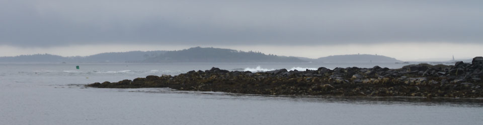
The White Islands are another “open” anchorage, protected from the SW by Big White and NE by Little White, Big Garden and Vinalhaven itself. But open to the NW and with only Hurricane Island to the SE. So I suppose all in all it’s pretty protected from most weather patterns.
The fog lifted after noon, and at 1:15 we were off, back to Muscle Ridge Channel. We had a light SW and sailed across to Otter Island, motored down to Whitehead, then motorsailed to Tenants Harbor. Paul went in to take on fuel and water and we convinced him over the VHF to pick up some more lobstah. We entered Long Cove once again and picked up a “Campbell” mooring near where we’d anchored the week before. There were a lot more boats than there had been then. Aurora returned and we dined again on Maine’s most famous delicacy.
We also plotted out possible stops on the return trip. The GPS was useful for this; entering waypoints from a list or off the map, and displaying the distances. Looked like we pretty much would have to retrace the trip up, returning to Jewell and Isles of Shoals before Boston; all pretty long days. The only alternative would be to make this the cruise and visit the Bays we were passing by: Boothbay, Muscongus and the like.
Part III, The Trip Back Down (chart-wise)
Tuesday, July 31
We finally visited Tenants Harbor itself, motoring in for fuel, water and ice at Cods End. Then it was off at 10 am for the trip back down (up wind) to Buzzards Bay. The first day was to retrace our steps back to Casco Bay, with no errant moves and familiarity with the lobster floats.
We again cut Fuller Rock at Cape Small, but this time the surf was roaring on the rocks, driven by a large storm out in the Atlantic. A huge roller passed in front of us as we reached deeper water. After it receded, we saw a small sailboat in the trough, looks of amazement on the faces of the crew. We did see a rainstorm but never touched it. Approaching Jewell Island was more interesting as we had to avoid the rocks guarding Casco Bay at that point. Somewhat remember dropping sail; we’d had them up all afternoon in hopes that we could in fact sail.
Our ST4000 autopilot had been unpredictable most of the trip so far – it might stay engaged for 30 minutes, or only for 30 seconds. And this after having been checked out by Raytheon last spring! I’d “solved” the problem by strapping a bungee cord around the clutch lever. During the afternoon, that had failed and we ended up with all auto, all the time. Odd that it failed engaged and not disengaged. So we had to steer dragging the belt around making horrible noises.
As we zigged around to the entrance, another boat appeared and headed in ahead of us. Just like approaching Hadley Harbor down by Woods Hole! As the day ends and you hope to reach the anchorage before everyone else, suddenly it seems like everyone else has the same idea. They dropped anchor at the end of one the rows of boats and we moved further in, amongst what looked like a Tartan rendezvous, and dropped anchor at 7:30. We spoke with Paul on the VHF, as he headed into Falmouth Foreside to leave Aurora, meet Sally and head back to Boston.
High tide came as we sat down to dinner, and again the seas flowed into the anchorage over the submerged rocks. The first wave, so to speak, knocked a bottle of seltzer off the table. Not ones to learn from experience, we sat down again to continue our meal. The next big one flipped our food, salad and again the seltzer onto the rug. A gimbaled table, perhaps?
We went to sleep lulled by the waves breaking on the rocks by the entrance. And it was warm enough to have the ports open again; we were moving south!
Wednesday, August 1
We were off by 9:00 through rolling seas around Green Island and out past Cape Elizabeth. Portland passed by in the haze. We could see why it is a nice place to live: on the ocean; cooler than lower parts of New England; and close by this great cruising area.
Up to now, we’d seen none of the creatures of the sea we’d hoped for. This morning we saw a fin and some shadowy bodies beneath the surface. Porpoise or shark? Once perhaps something surfaced behind us; but when I turned there was only roiled water. Was it only a breaking wave?
We sort of sailed in the early afternoon, but it was for the most part another day of motoring. We reached Isles of Shoals at 6:30 and grabbed what was the last mooring in the inner cove. It was almost the full moon, and the surf crashed over the seawall to the southeast at high tide.
Thursday, August 2
Another early start at 8:30 for what we figured would be a long day. Little did we know! A SW was predicted (so what’s new?) and we considered rounding Cape Ann so we could sail and have a change from the Annisquam River. White smoke and a breathy sound to the exhaust changed all that.
The Yanmar sounded different immediately as we motored out of the Isles. Not much water seemed to be coming out of the exhaust, although there was much white smoke or steam. As soon as was feasible, the sails went up and the motor was shut down. I took everything apart, beginning with the Groco strainer and followed up by the raw water pump. The strainer was free of seaweed and the impeller looked fine. So what was wrong? I looked through my diesel manual and how-to book, but discovered no magic solution. I had topped off the lube oil the evening before and slightly overfilled it. Was this the problem? This can cause overheating according to what I’d read.
We worked on sailing south, but slowly the wind died. When we tacked east, towards Europe, we were slowed by the large seas still rolling in. And to the west, we were headed towards Newburyport. That’s windward sailing, of course, but now we were dealing with an uncertain motor. Eventually we turned it on and headed towards, yes, the Annisquam. Just about here we had encountered exhaust problems in Paul’s boat several years ago. The fitting on his waterlift muffler had parted and he was able to repair it only because he had a can of PVC cement on board.
The smoke or steam stayed light as we headed into the river. The beaches were crowded with bodies and beached powerboats as the population escaped that week’s heat wave. Halfway down the channel, the overheat alarm went off and I quickly anchored next to the floating food vendor. After starting off again, it had taken us from 3:00 to 5:00 to get through, with the cooling pit stop.
We headed southwest towards Boston at a plodding 4 knots. After another attempt to sail exiting Gloucester Harbor, we just motored at low RPMs. I kept thinking of what I could have done wrong with the diesel and would we still be sailing if our boat were able to point higher?
The sun set as we passed Salem and the thought passed that we could stop again at Great Misery, even better named this time. We even had to divert to the east to pass the green flashing “1.” But the smoke/steam was not so extreme now and Boston offered the hope of mechanics and the like, along with being home if indeed we could not continue. As darkness fell, I called Boat/U.S., thinking of getting a tow the rest of the way. They did not have a boat but promised call again when we reached the North Channel.
Again we had the unfamiliar “entering a harbor at night” to go through. Lots of lights on the shore and in the water; lots of marks in the GPS to choose from. We were familiar with Boston Harbor from years of sailing there, but it all looked different at night. We reached the North Channel marker just as Boat/U.S. called on the cell phone and Nan had to yell, don’t hit that thing! We were also in touch with David and Jody Williams, whom we’d last seen in Onset as they headed south the day we were headed north. They were awaiting our arrival on their mooring at the Cottage Park YC in Winthrop.
So it was a looooong evening as we zigzagged down the channel, red by red, the Deer Island sewage treatment plant blazing with light to starboard and assorted islands and lights ahead and to port. It was a puzzle to figure out which was the next light or pair of lights, using the binoculars and the GPS. And through the glasses, distances were deceptive, making it look like the mid-harbor islands were actually closer than they were. It was 11:30 when we picked up the slimy mooring pennant (well, they’d been in a slip for several weeks).
Friday, August 3
Things’ll look better in the morning and they did. All fluids were fine, no loose liquids in the pan and no smoke in the exhaust. It was with great relief that we rowed to the floats and met up with David in the daylight. It was fun to see the Boston skyline on a weekday morning and know that we weren’t going into the city to work. Or, now it seemed, to be repairing Jabberwocky either.
We took care of the two cruising needs once again at the CPYC and took David’s car into town to provision one last time. At noon we were fueling up at Crystal Cove and at 12:30 we had sails up (!) and we were headed through the familiar islands of the harbor. Finally we were relaxed again after the strain of the uncertain motoring and the night’s adventure. Past Nix’s Mate, between Lovell and Georges Islands and out past Peddocks Island and Hull Gut. Out of the harbor and around Hull and down the coast, reaching Minot’s Light 3:00 where we made the final turn-in towards Scituate.
A co-worker had offered to let us raft up to his Tartan 30, and as we studied the chart of the harbor, he called on the cell phone! He didn’t think he’d make it out to the boat, but the offer still stood. The wind had picked up, and we had the same warm breeze/cool breeze alternation we’d had in Maine. We seemed to sail slowly in the warm one and faster in the cold.
It looked like a storm was brewing and with the wind we decided that rafting to an unoccupied boat was not a good idea. We called for a mooring service on the VHF and someone replied that we wanted to call the Cedar Point launch. We did and were set up to meet said launch inside the breakwater. Cost was $25, including launch service and showers.
They offered to place us in the inner harbor; I demurred and we were given the first mooring inside the harbor. It would be an uncomfortable spot in a blow, but had a great view of the harbor to the west and the lighthouse immediately to the east. I had great thoughts of sunset and sunrise photos until the sky completely clouded over. (I also did not know that the camera was not working and hadn’t been since our arrival at Tenants Harbor the week before.) We also had a front-row view of the illumination of the harbor, which unfortunately coincided with the arrival of a thunderstorm.
We ate below and then moved to the V-berth, where we lay backwards so that we could watch the storm through the hatch. Ah, shipboard romance!
Saturday, August 4
On schedule, amazingly enough for the end of a two-week cruise, we headed south from Scituate into Cape Cod Bay. We had fog worthy of Maine and the promised west wind did not of course appear. For much of the trip we blew our air horn and hoped that the powerboats we could hear would not be hitting us.
The white smoke/steam had returned to the exhaust, although not the breathy sound accompanying the extreme shortage of water we’d had two days before. The current turned at 3 pm and that’s when we arrived at the east end of the Cape Cod Canal. With its help, we were through in an hour and at 4:15 we were tied up at the Onset Town Pier for the unloading. Time for another shower.
The overheating / water flow problem was solved a couple of weeks later, after checking everything all over again, including the hull intake. A mechanic came out one afternoon and finally connected the hose from the seacock directly to the water pump, bypassing the Groco. Much water; just like normal! Pulling the feed hose off the filter, out fell two of the soft, tubular type barnacles that were living or had floated there. So simple, yet not visible to the eye. And now I think there’s one in the head intake seacock!
Weather – Have to figure that we beat the odds here: a day and a half of rain and day and a half day of fog; one day combining both.
Wind – I’d have to say that we motored a lot more than expected. We anticipated having to drive back into the SW wind, but still hoped to get some sailing in. Overall we perhaps motored 7 days out of the 14. In shorter cruises around Buzzards Bay, we’ve but once had to motor that much. And in the three weeks we’ve spent in the Leeward Islands, the Trade Winds kept us sailing except when we were in the lee of the islands.
Anchoring and mooring – We had moorings on 8 occasions, only paying for them in North Haven ($10) and Scituate ($25). The ones at Great Misery Island are supposedly free if you’re not going ashore. At Long Cove the holding was such that a mooring is not needed. (Our anchor is a 22# S-L Claw, Bruce clone.) At Isles of Shoals, I believe that the holding is very poor, and don’t know what we’d have done if no moorings had been available.
Guides – We had a new ChartKit and Embassy Guide, along with the (old) second edition of Tafts’ Cruising Guide to Maine and a large-scale NOAA chart of the entire area. Each was useful in its own way. The large chart kept us located overall and provided reference where we might fall off the edge of a ChartKit page. The latter was invaluable in providing all scales of charts for the trip, almost always well sectioned into useful navigation areas. The Tafts had the most complete descriptions of all possible anchorages, while the Embassy offered details about onshore services in populated harbors.
Gear – Two new items that worked were BugBuster screens for the foredeck hatch and the companionway. They fit well and did keep the little critters out (and they were there). The Garmin GPSmap 76 with shoreline detail added from the Waterways & Lights CD was a great help in navigating the unfamiliar waters. And a birthday present of a Pelican StealthLite flashlight was great, but really too strong for reading charts in the cockpit.
Improvements – New overhead lights below, including one added over the dining table, gave excellent light at night and the red was strong enough to be useful while under way and for nocturnal amblings. A removable shelf attached to the end of the settee, next to the stove, made a great addition to the galley. A Balmar alternator and regulator plus a Unisolar panel on the sea hood kept the batteries well charged. (Certainly the amount of motoring we did didn’t hurt.) No belts were eaten as we had been warned about.
Food – Much to our amazement, we ate every meal on the boat with the exception of the visit to Bayside and breakfast in Winthrop. Several pieces of pre-cooked barbeque chicken provided lunch every day for the trip up. We had steak twice, the first night out and another one from North Haven, and lobster twice. We made great use of some freeze-dried camping meals; the Mountain House brand was actually edible. We also had canned chili from Trader Joes and many varieties of instant potatoes and rice. I’m sure something is forgotten here; we couldn’t have eaten that much prepared food! We went through three sets of ice (3 blocks each) to handle the two weeks.
Provisioning – We stocked up twice during the trip, once at Brown’s in North Haven and once before heading back at Cod’s End at Tenants Harbor. Well, we topped off at the new Winthrop Market before leaving Boston. Both places in Maine had a good selection of staples and meats (particularly Brown’s) plus ice and the like. Cod’s End took garbage; Brown’s didn’t. Besides the difficulty getting to Brown’s fuel dock, they had the highest pressure diesel hose I’ve come across; meant for lobstah boats – watch out!
Pump-out – We have become spoiled in the no-discharge zone of Buzzards Bay, where pump-out stations and boats are everywhere. We never saw either in Maine and according to the Embassy Guide, we didn’t even come very close to one. If the government wants us to carry this stuff around, it would be nice to have some help in disposing of it.
Clothing – We brought light stuff, shorts and T-shirts, for daytime and heavier knits and fleece for the evenings. The latter turned out to be needed by mid-afternoon in the cool sea breeze. Our Henri-Lloyd foul weather gear really got used only the last afternoon back in Cape Cod Bay. Didn’t try any swimming!
Safety – I’d installed padeyes in the cockpit last spring, and we harnessed ourselves in the night we motored to Boston. (We have a pair of West Marine offshore-type inflatable harnesses.) We had a jackline along the side deck, but not being under sail we had no need to go forward.
Communications – Cell phone service (Cingular) was only available some of the time. No service at Tenants Harbor, but fine over at the SW end of Vinalhaven. At Isles of Shoals the Nokia couldn’t decide between the Maine and the New Hampshire providers.